


According to the World Bank, in 2020, approximately 4.4 billion people (more than half of the global population) live in urban areas. Therefore, cities have been increasingly put under pressure to anticipate and adapt to this trend and its induced changes. The speed and scale of this concentration have led to growing needs and, notably, an increasing demand for well-connected transportation systems.
As if a skyrocketing demand was not enough, usage patterns have also been disrupted in the past few years: Remote working has been generalized with the health crisis and new mobilities have been on the rise. For a large proportion of the urban population, “commute, work, sleep” is not a reality anymore. Most workers choose not to go to work everyday or not to take traditional public transportation networks such as bus lines, tram, or metro, but rather take dockless bicycles or electric scooters. During the health crisis, public transit ridership has fallen from as much as 90%, according to McKinsey.
Therefore, cities need to have a more granular and detailed understanding of mobility patterns than before. They also need to continuously anticipate change and therefore be able to forecast future traffic.
Data Collection Needs to Be Structured and Comprehensible
Good news, collection of data has risen at the same time and can help cities get an overall picture of the urban transportation networks to keep on improving them. The ultimate goals are to both achieve sustainable long-term development of the city and economic growth.
However, there is still a lack of detailed reports on mobility in cities: Multidisciplinary Digital Publishing Institute reported only about 100 mobility-related publications in 2021. Moreover, the combination of multiple data sources is still a challenge for most stakeholders.
AI-Enhanced Mobility Modal Analysis Can Help Get Cities on Track
AI comes in as an ally to enhance traffic analysis and prediction across the whole city. With faster, more flexible data wrangling and processing, analytics and AI become the must-have practice to improve city planning.
But embarking on such a journey demands finding the right starting points, and that’s why Dataiku is excited to introduce its latest Business Project: Multimodal Analysis & Traffic Forecasting. It is meant for city planners and managers in public administration to help them benefit from a combination of multiple data sources to improve traffic monitoring and forecasting. It is the first step toward embedding AI in a holistic city planning strategy.
How Does It Work in Practice?
The goal of this Multimodal Analysis and Traffic Forecasting project is to provide mobility stakeholders with a data-driven project that will help them in better understanding of the latest user trends (how often people travel, what modes of transportation are used most, etc.), visualize future construction sites to identify their potential impact on transportation, and anticipate congestion by forecasting traffic in multimodal transportation hubs.
This project focuses on the city of Paris. The data comes from Open Data Paris and Ile-de-France Mobilités, but the template of the project can be used in another city.
With this project, city planners and managers in the public administration will be able to:
- Anticipate and limit the impact of traffic congestion (e.g., provide a relevant transportation alternative when major construction is planned).
- Take measures to improve user satisfaction (e.g., offer new subscription options).
- Improve or redesign urban transport to meet user needs and environmental objectives (e.g., plan the installation of new bicycle paths).
From a user perspective, the project is made of the following easy-to-use components:
1. A Structured and Comprehensive Flow
Adapt the flow to the city specificities and ingest all relevant data to improve and enrich the monitoring and forecasting of the traffic.

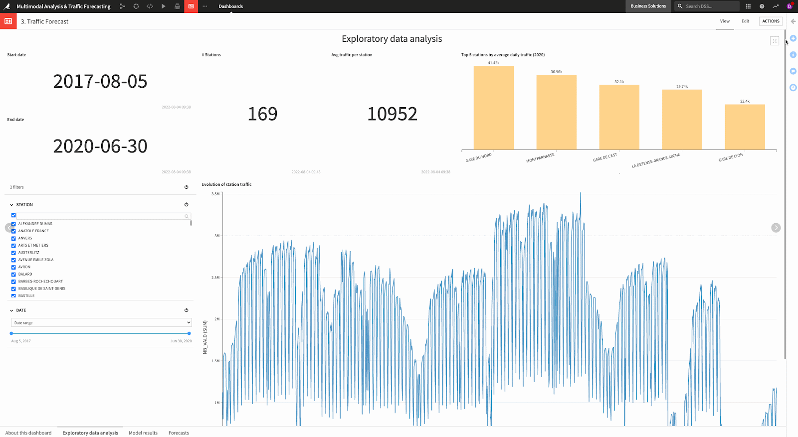
2. User-Friendly Interactive Dashboards for Operational Insights
Transform the data from your different systems into a unified view where you can get operational insights at different granular levels (weekly patterns, monthly patterns, etc.).

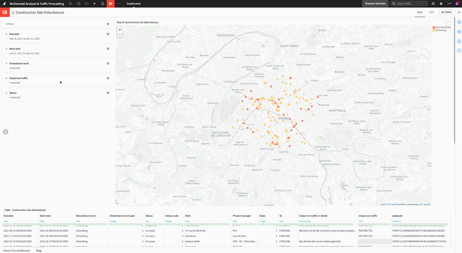
3. Interactive Analysis of Construction Works in Your City
Use Dataiku’s advanced analytics capabilities to understand where the main bottlenecks for mobility in your city are.
4. Easy Time Series Model Training to Learn From Your Historical Validation Data
Understand the future traffic to enable data-driven actions such as the opening of new bus lines or special bus lines for events, encouraging micro-mobility operators to put vehicles near the areas of congestion.
5. Model Deployment to Share It With Other Stakeholders (Public, Private) to Enable Collaboration and Get More Insights
Models can be enriched with data that comes from different mobility stakeholders and sharing the model with those different stakeholders fosters collaboration. For example, adding the micro-mobility data of the city to the current model could enable a more accurate forecast of the traffic.
Start improving your monitoring and forecasting of traffic with these simple requirements:
- Dataiku 11
- Plugins: API Connect and Time Series Preparation. Learn how to install a Dataiku plugin here.
Required packages for this code env are:
statsmodels==0.12.2gluonts==0.8.1pmdarima==1.2.1mxnet==1.7.0.post2scikit-learn>=0.20,<0.21scipy>=1.2,<1.3xgboost==0.82lightgbm>=3.2,<3.3jinja2>=2.10,<2.11MarkupSafe<2.1.0flask>=1.0,<1.1cloudpickle>=1.3,<1.6